Google

Thursday, January 31, 2008

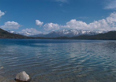
Rara Lake


In the western part of the country, this area is protected by the Rara National Park. At 106 sq km, it is the smallest national park of Nepal.

Rara is a good destination point for trekking in the west. The trail is very much "off the beaten path" and affords glimpses of culture and scenery very different from those in the rest of the country. The centerpiece of the park is the biggest lake of Nepal.

Along mountain paths and a series of picturesque villages, one reaches the magnificent banks of Rara lake. The park includes Trans- Himalayan valley with high ridges covered with forest and alpine pastures. Being among the local people with their distinctive culture and traditions, gives the visitor a unique experience and makes for a wonderful holiday. The primitive people give the trekker a look backward and a chance to reflect on his own modern society and development.

The great high mountains scenery enchants and fascinate as always. Like most of Nepal, Rara National Park is a naturalist's dream. Animals like the gaur, serow, musk deer, yellow-throated martin and a wide variety of birds such as the impeyan pheasant, kalij and dove are ever present.

Gosainkunda!


One of Nepal's most famous religious places of pilgrimage is Gosainkunda lake situated at an altitude of about 4360m. Surrounded by high mountains on the north and east, this lake is grand and picturesque. There are other nine famous lakes such as Saraswati, Bhairav, Sourya and Ganesh Kunda. Every year during Janai Purnima in August, thousands of Hindu pilgrims come here to lake holy bathe in the lake. The large rock in the center of the lake is said to be the remains of a Shiva shrine and it is also claimed that channel carries water from the lake directly to the tank at the Kumbheshwar Temple in Patan, 60 km to the south.
The best approach to Gosainkunda is through Dhunche, 132 kilometers north-east of Kathmandu. Dhunche is linked with Kathmandu by a motorable road. The trekking to Gosainkunda from Dhunche takes two days.
Gosainkunda Lake, a sacred lake for both the adherents of Hindu and Buddhist faiths, is also known for wonderful scenery. Ringed by high mountains on the northern and eastern sides, the lake offers a fascinating sight. In addition to its status as a place of religious importance, the Lake also offers stiff challenge to the trekkers.

Tuesday, January 29, 2008

Kagbeni


Kagbeni is situated in the valley of the Kali Gandaki, This river is one of three who cross the Himalayas. The Kali Gandaki was one of the major trading routes between Tibet and India. The traders brought the famous salt from Tibet and barley, spices and clothes from India. After the Chinese invasion in Tibet the trade came to an halt and many of the rich villages lost their revenue and later many people. Nowadays, there is again a some trade, but also now the income from Tourism.
Kagbeni is just a 2 hour side trek from the shortest route from Muktinath to Jomsom. But it is one of my favourite villages in the whole Annapurna region and it really a pity, if you miss it
Kagbeni means literally” bolt at the two rivers” and formerly controlled the trade. One can see this past as a fortified village, as all the houses are build in a common rectangle which a common outer wall and just three little entrance doors. The former fortress is nowadays in ruin


Phokshundo Lake


Dolpa is the largest district of Nepal is in the Mid-western part of the kingdom covers about 793230 hectors of the total land of the country. According to the census of 2001 A.D (2058 B.S) The total population of the district is 29584. about the naming of the district once there reach an English people called charka from tibet to Dho-Tarap village, by the same of the village Dho it become Dholpa later on the people used to say the same Dholpa as Dolpa. In Tibetan language Dolpa is famous as Tholbho.This district is very far from the capital of the country. Dolpa is very back from the development point of view. But Dolpa district is a natural collection of high passes, rare fauna and sweeping vistas. Which is enriched by the traditional Tibetan cultural heritage? Phoksundo the deepest lake of Nepal is also in the same district which is 650 m deep. The district Dolpa is also known as Caravan's district. The film named caravan was selected for Oscar award. words rare and valuable medical plants like panch ayule, guchhi chayu and yarshagumba are also available in this district.


Phoksundo Lake, also known as Phoksumdo Lake, is the deepest lake in Nepal.


Dolpo is an ancient Tibetan kingdom located in the north east part of Nepal. It was only opened to trekkers in 1990. The Himalayan range can be seen in all its splendor, and Phoksondo lake with the Ringmo village provide some of the most beautiful Nepalese scenery. We follow the ancient Tibetan salt caravan route, across two high passes and through the wilderness in one of Nepal’s most remote areas. In the Dolpo region the monsoon, created by the sea winds blowing from the Gulf of Bengal, is tempered by the Dhaulaghiri range and trekking is therefore also possible during the summer, a period during which flora explodes in all its splendor: orchids, edelweiss, campanules, forget-me-nots.


Phoksundo is also known as rigmo Lake. The lake is in the height of 3613m from the sea level. The total area of the lake is 6.78 square kilometer. The length of the lake is 4.8 km north to south and width of the lake is 1.6 km east to west. Phoksundo Lake is in phoksundo v.d.c except this lake there are so many other small lakes and ponds in dolpa. among them some are as follows. sundaha, khalital, sakudaha, chumkanatal etc.


Why is the phoksundo lake have an unearthly turquoise blue color?


Its located in one of Nepals many mountainous regions. It takes its colour due to the rock flour that enters it from the glaciers in the mountains. The glaciers grind the rocks to very fine particles and they create a turquoise blue colour while suspended in the water. Many glacial lakes have this characteristic.

Phewa Lake

Phewa lake is the second largest lake of Nepal and the largest lake of Pokhara Valley. IT is situated at an altitude of 784m at the western edge of Pokhara city near Baidam. It covers an area of about 4.43 sq km with an average depth of about 8.6m, maximum water depth is 19m. The maximum water capacity of the lake is estimated to be 46 million cubic meters. It lies in the valley of Harpan Khola which feeds the lake. On the southern mouth of the lake, at the crown of Pardi River, a dam is built which has nearly doubled the water level. The water of the lake is used for irrigation and electricity generation.
The lake is surrounded by Sarangkot and Kaskikot hills on the northern side. The hill running along the lake is Raniban (Queen of Forests) which is very rich in flora and fauna. Mammals like Common leopard, Bengal fox and Barking deer are common in this forest. It is a home of abundant avifauna also.
The first main attraction is the pagoda style temple in the lake which is the shrine of Barahi (Water Goddess). The next main attraction is the mirror image of mount Machhapuchhre and Annapurna range on the crystal clear water of the lake. The south - eastern side of the lake offers the best view. THere is facility of canoeing and fishing.
Phewa originally used to cover an area of 9 sq km but now has been reduced to 4.43 sq. km. Geologically the rocks of either side of Phewa are slate and quartzite and make anticline
structure along the axis of the lake.


The lake is the home of 17 species of native fish and 4 exotic species. The forest and lake is the habitat of 6 species of amphibians, 14 species of reptiles, 34 species of mammals and 104 species of birds. Out of 104 species of birds, 14 are migratory species.
The lake is linked with pitched vehicle road and boating facility is available.

Annapurna


Annapurna is a series of peaks in the Himalaya, a 55 km (34 mi)-long massif whose highest point, Annapurna I, stands at 8,091 m (26,538 ft), making it the 10th-highest summit in the world and one of the 14 "eight-thousanders". It is located east of a great gorge cut through the Himalaya by the Kali Gandaki River, which separates it from the Dhaulagiri massif. (Dhaulagiri I lies 34 km/21 mi west of Annapurna I.) Annapurna is a Sanskrit name which is translated as Goddess of the Harvests. In Hinduism, Annapurna is a goddess of fertility and agriculture and an avatar of Durga.


Annapurna I was the first 8,000-metre (26,200 ft) peak to be climbed. Maurice Herzog and Louis Lachenal, of a French expedition (including Lionel Terray, Gaston Rébuffat, Marcel Ichac, Jean Couzy, Marcel Schatz, Jacques Oudot, Francis de Noyelle), reached the summit on 3 June 1950. (See the documentary of the expedition "Victoire sur l'Annapurna" by Marcel Ichac).
The south face of Annapurna was first climbed in 1970 by Don Whillans and Dougal Haston, members of a British expedition led by Chris Bonington which included the alpinist Ian Clough, who was killed by a falling ice-pillar during the descent.


In 1978, The American Women's Annapurna Expedition, a team led by Arlene Blum, became the first American team to climb Annapurna I. The expedition was also remarkable for being composed entirely of women. Sadly, Alison Chadwick-Onyszkiewicz and Vera Watson died during this climb. (Vera Watson was the wife of computer scientist John McCarthy.)
On 3 February 1987, Polish climbers Jerzy Kukuczka and Artur Hajzer made the first winter ascent of Annapurna I. The Annapurna peaks are among the world's most dangerous mountains to climb, with a fatality rate of 40%.[1] As of 2005, only 103 successful summits have been made, for the loss of 56 lives, many to the avalanches for which the mountain is known. Climbers killed on the peak include famed Russian climber Anatoli Boukreev in 1997 and Christian Kuntner in 2005

Machhapuchhre (Fishtail) (6993m)


The shining peak of Machhapuchhre, which means "Fishtail" in Nepali, sits elegantly in the faint atmosphere of mist beyond the silhouette of a lone tree.
Machhapuchre as seen from the Pokhara region is in th center of the Annapurna Himal. It possesses a dignity and beauty which makes one forget it is not quite 7000m in elevation. Machhapuchhre exhibits the rare beauty that makes it one of the world's most famous peaks.

Mount Everest


Mount Everest, or Sagarmatha is the highest mountain on Earth, as measured by the height of its summit above sea level. The mountain, which is part of the Himalaya range in High Asia, is located on the border between Nepal and Tibet, China. By the end of the 2006 climbing season there had been 3,050 ascents to the summit by 2,062 individuals, and at least 630 more ascents in 2007.There have been more than 200 deaths on the mountain, where conditions are so difficult that most corpses have been left where they fell; some are visible from standard climbing routes.
Climbers range from experienced mountaineers to relative novices who count on their paid guides to get them to the top. This means climbers are a significant source of tourist revenue for Nepal, whose government also requires all prospective climbers to obtain an expensive permit, costing up to $25,000 (USD) per person.

Radhanath Sikdar, an Indian mathematician and surveyor from Bengal, was the first to identify Everest as the world's highest peak in 1852, using trigonometric calculations based on measurements of "Peak XV" (as it was then known) made with theodolites from 240 km (150 miles) away as part of the Great Trigonometric Survey of India. Measurement could not be made from closer due to a lack of access to Nepal. Peak XV was found to be exactly 29,000 feet (8,839 m) high, but was publicly declared to be 29,002 feet (8,840 m). The arbitrary addition of 2 feet (0.6 m) was to avoid the impression that an exact height of 29,000 feet was nothing more than a rounded estimate.
More recently, the mountain has been found to be 8,848 m (29,028 feet) high, although there is some variation in the measurements. The mountain K2 comes in second at 8,611 m (28,251 ft) high. On May 22, 2005, the People's Republic of China's Everest Expedition Team ascended to the top of the mountain. After several months' measurement and calculation, on October 9, 2005, the PRC's State Bureau of Surveying and Mapping officially announced the height of Everest as 8,844.43 m ± 0.21 m (29,017.16 ± 0.69 ft). They claimed it was the most accurate measurement to date.[9] This height is based on the actual highest point of rock and not on the snow and ice covering it. The Chinese team also measured a snow/ice depth of 3.5 m,[10] which is in agreement with a net elevation of 8,848 m. The snow and ice thickness varies over time, making a definitive height of the snow cap impossible to determine.


Everest was formed about 60 million years ago. It was named after Sir George Everest in 1865 ,the British surveyor-general of India. Once known as Peak 15. Its location is Latitude 27° 59' N.....Longitude 86° 56' E It's summit ridge seperates Nepal and Tibet. First ascent was done by May 29,1953 by Sir Edmund Hillary, NZ and Tenzing Norgay, NP, via the South Col Route. The most dangerous place is Khumbu Ice Fall-19 deaths.Highest cause of death is Avalanches-about a (2:1) ratio over falls.